
My Mapmaking Process
How I Make a Map
My first map seemed to take endless hours to create, but I've since found a rhythm that allow me to work more efficiently. To date, I've created upwards of 75 maps. I want to show you my process.
Supplies
I use one pen and one brush exclusively for everything I paint. (Here's a fantastic video on why watercolor brushes are expensive!) My favorite watercolor paper is Twinrocker Handmade Paper from Indiana. Since it's handmade to size, it has a glorious deckle edge that's stunning.

1 Research
I ALWAYS use multiple reference maps so I don't rip off anyone's work. USGS, tourist sites, city websites and Google Earth are my go-tos. For example, it took a week of combing through park maps and hiker blogs to research The Cascade Range. I overlay multiple maps in Adobe Illustrator and toggle between them as I draw. This is where my background in graphic design comes in handy. Here's what my screen looks like:

2. Pencil Drawing
I lightly grid the paper. The grid guides my overall drawing and keeps me accountable to the overall shape. I draw freehand within this grid. I start with the biggest overall shapes then add interior details like counties, lakes and cities. I'm able to write in a very straight line without a ruler, but I still write out every word to reduce spelling mistakes. I make sure to plan spacing carefully so I don't write a county name right where a mountain needs to go!

3. Inking
It can take hours of ideation to find the title. In this example, I based the title on a vintage font, but kept it handwritten. Often the drawing needs a compass or additional vignette to balance out the composition. Then, I use a LAMY fountain pen filled with DeAtramentis waterproof ink so my linework won't disappear when I paint. This step is fun! I can listen to podcasts, which I can't do during the initial drawing because my brain is too busy. Then I have an aggressive erasing session to remove the pencil grid.

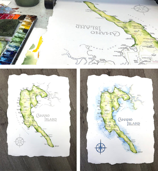
4. Painting
At this point in the process, I've invested HOURS into the drawing, and watercolor dries quickly, so I work as fast as possible. I'm constantly evaluating - is there enough color variation? Is there a spot that's about to dry that I won't be able to change? Is the topography accurate? Surprisingly, painting is one of the shortest steps in the process. Below, you can see how I sometimes turn the paper upside down when I paint to get a different perspective.
5. The Finished Map
I hang onto the originals to sell at art festivals, but sometimes I pre-sell them through social media. While selling an original feels great, I'm most passionate about having my work affordable and accessible. The more people that have my art, the happier it makes me.

It's taken me many years to build a satisfying process. I'm continually learning and experimenting as I go.